ที่อยู่: 8700 (From 8700 To 8799) COUNTY ROAD 30, GALION, OH 44833-9068, USA
44833-9068คืออะไร 44833-9068 เป็นรหัสไปรษณีย์ห้าบวกสี่หลัก 8700 (From 8700 To 8799) COUNTY ROAD 30, GALION, OH, USA มีรายละเอียดดังต่อไปนี้
44833-9068 ข้อมูลพื้นฐาน

-
รหัสไปรษณีย์ 5 พลัส 4:
44833-9068 -
รหัสไปรษณีย์ 5:
44833 -
พลัส 4?90684-digits that are used to identify a geographic segment within the 5-digit delivery area, such as a city block or a group of apartments or an individual high-volume receiver of mail, or any other unit that could use an extra identifier to aid in efficient mail sorting and delivery. This code is the low end of the range of +4 Codes that pertain to this ZIP Code. ZIP+4 Codes associated with nondelivery areas are composed of valid ZIP sector numbers and "ND" for the ZIP segment number, for example 12345-12ND. Non-deliverable areas are areas to which the USPS does not deliver mail, such as vacant lots and land that borders railroad tracks. Mailers should not match an address identified as a nondelivery area. If you absolutely must have numeric characters in the Plus4Code column, you may treat "ND" values as "00" (zero zero).:
-
ประเทศ:
U.S. - ประเทศสหรัฐอเมริกา -
รัฐ:
OH - โอไฮโอ -
อำเภอ:
CountyFIPS: 39117 - Morrow County -
เมือง:
GALION -
ถนน?COUNTY ROAD 30The official name of a street as assigned by a local governing authority. The Street Name column contains only the street name and does not include directionals (EAST, WEST, etc.) or suffixes (ST, DR, BLVD, etc.). This element may also contain literals, such as PO BOX, GENERAL DELIVERY, USS, PSC, or UNIT. Numeric street names that have numeric components that are four characters (or less) in length at are justified such that the low-order digit of the number is positioned in the fourth position of the street name column. This shift is made so that the numeric street names appear in numeric sequence.:
-
ประเภทระเบียน?S: ถนนAn alphabetic value that identifies the type of data in the record. Record type codes include the following: G = General delivery H = Highrise F = Firm S = Street P = PO box R = Rural route/highway contract:
ที่อยู่

- ตัวเลขหลักต่ำของที่อยู่หลัก?
A house, rural route, highway contract box, or post office box number; the numeric or alphanumeric component of an address preceding the street name; the low-end address in a range of addresses. Often referred to as house number.: 8700
- ตัวเลขหลักสูงของที่อยู่หลัก?
A house, rural route, contract box, or Post Office box number. The numeric or alphanumeric component of an address preceding the street name. The high-end address in a range of addresses. Often referred to as house number.: 8799
- เลขคี่ / เลขคู่ที่อยู่หลัก?
Code that identifies the side or sides of a street for which a given address range is applicable. For street, highrise, firm and multi-carrier records, B = Both sides of a street, E = Even side of a street (even-numbered addresses in the range); O = Odd side of a street (odd-numbered addresses in the range). For general delivery, post office box, and rural route/highway contract records, this code will always be "B" (both).: Both of Odd and Even
- หลัก เทือกเขา: 8700, 8701, 8702, 8703, 8704, 8705, 8706, 8707, 8708, 8709, 8710, 8711, 8712, 8713, 8714, 8715, 8716, 8717, 8718, 8719, 8720, 8721, 8722, 8723, 8724, 8725, 8726, 8727, 8728, 8729, 8730, 8731, 8732, 8733, 8734, 8735, 8736, 8737, 8738, 8739, 8740, 8741, 8742, 8743, 8744, 8745, 8746, 8747, 8748, 8749, 8750, 8751, 8752, 8753, 8754, 8755, 8756, 8757, 8758, 8759, 8760, 8761, 8762, 8763, 8764, 8765, 8766, 8767, 8768, 8769, 8770, 8771, 8772, 8773, 8774, 8775, 8776, 8777, 8778, 8779, 8780, 8781, 8782, 8783, 8784, 8785, 8786, 8787, 8788, 8789, 8790, 8791, 8792, 8793, 8794, 8795, 8796, 8797, 8798, 8799.
โปรดคลิก "ตัวอย่างที่อยู่เพิ่มเติม" เพื่อดูรายการทั้งหมด
8700 COUNTY ROAD 30, GALION, OH 44833-9068
8701 COUNTY ROAD 30, GALION, OH 44833-9068
8702 COUNTY ROAD 30, GALION, OH 44833-9068
8703 COUNTY ROAD 30, GALION, OH 44833-9068
8704 COUNTY ROAD 30, GALION, OH 44833-9068
8705 COUNTY ROAD 30, GALION, OH 44833-9068
8706 COUNTY ROAD 30, GALION, OH 44833-9068
8707 COUNTY ROAD 30, GALION, OH 44833-9068
8708 COUNTY ROAD 30, GALION, OH 44833-9068
8709 COUNTY ROAD 30, GALION, OH 44833-9068
8710 COUNTY ROAD 30, GALION, OH 44833-9068
8711 COUNTY ROAD 30, GALION, OH 44833-9068
8712 COUNTY ROAD 30, GALION, OH 44833-9068
8713 COUNTY ROAD 30, GALION, OH 44833-9068
8714 COUNTY ROAD 30, GALION, OH 44833-9068
8715 COUNTY ROAD 30, GALION, OH 44833-9068
8716 COUNTY ROAD 30, GALION, OH 44833-9068
8717 COUNTY ROAD 30, GALION, OH 44833-9068
8718 COUNTY ROAD 30, GALION, OH 44833-9068
8719 COUNTY ROAD 30, GALION, OH 44833-9068
8720 COUNTY ROAD 30, GALION, OH 44833-9068
8721 COUNTY ROAD 30, GALION, OH 44833-9068
8722 COUNTY ROAD 30, GALION, OH 44833-9068
8723 COUNTY ROAD 30, GALION, OH 44833-9068
8724 COUNTY ROAD 30, GALION, OH 44833-9068
8725 COUNTY ROAD 30, GALION, OH 44833-9068
8726 COUNTY ROAD 30, GALION, OH 44833-9068
8727 COUNTY ROAD 30, GALION, OH 44833-9068
8728 COUNTY ROAD 30, GALION, OH 44833-9068
8729 COUNTY ROAD 30, GALION, OH 44833-9068
8730 COUNTY ROAD 30, GALION, OH 44833-9068
8731 COUNTY ROAD 30, GALION, OH 44833-9068
8732 COUNTY ROAD 30, GALION, OH 44833-9068
8733 COUNTY ROAD 30, GALION, OH 44833-9068
8734 COUNTY ROAD 30, GALION, OH 44833-9068
8735 COUNTY ROAD 30, GALION, OH 44833-9068
8736 COUNTY ROAD 30, GALION, OH 44833-9068
8737 COUNTY ROAD 30, GALION, OH 44833-9068
8738 COUNTY ROAD 30, GALION, OH 44833-9068
8739 COUNTY ROAD 30, GALION, OH 44833-9068
8740 COUNTY ROAD 30, GALION, OH 44833-9068
8741 COUNTY ROAD 30, GALION, OH 44833-9068
8742 COUNTY ROAD 30, GALION, OH 44833-9068
8743 COUNTY ROAD 30, GALION, OH 44833-9068
8744 COUNTY ROAD 30, GALION, OH 44833-9068
8745 COUNTY ROAD 30, GALION, OH 44833-9068
8746 COUNTY ROAD 30, GALION, OH 44833-9068
8747 COUNTY ROAD 30, GALION, OH 44833-9068
8748 COUNTY ROAD 30, GALION, OH 44833-9068
8749 COUNTY ROAD 30, GALION, OH 44833-9068
8750 COUNTY ROAD 30, GALION, OH 44833-9068
8751 COUNTY ROAD 30, GALION, OH 44833-9068
8752 COUNTY ROAD 30, GALION, OH 44833-9068
8753 COUNTY ROAD 30, GALION, OH 44833-9068
8754 COUNTY ROAD 30, GALION, OH 44833-9068
8755 COUNTY ROAD 30, GALION, OH 44833-9068
8756 COUNTY ROAD 30, GALION, OH 44833-9068
8757 COUNTY ROAD 30, GALION, OH 44833-9068
8758 COUNTY ROAD 30, GALION, OH 44833-9068
8759 COUNTY ROAD 30, GALION, OH 44833-9068
8760 COUNTY ROAD 30, GALION, OH 44833-9068
8761 COUNTY ROAD 30, GALION, OH 44833-9068
8762 COUNTY ROAD 30, GALION, OH 44833-9068
8763 COUNTY ROAD 30, GALION, OH 44833-9068
8764 COUNTY ROAD 30, GALION, OH 44833-9068
8765 COUNTY ROAD 30, GALION, OH 44833-9068
8766 COUNTY ROAD 30, GALION, OH 44833-9068
8767 COUNTY ROAD 30, GALION, OH 44833-9068
8768 COUNTY ROAD 30, GALION, OH 44833-9068
8769 COUNTY ROAD 30, GALION, OH 44833-9068
8770 COUNTY ROAD 30, GALION, OH 44833-9068
8771 COUNTY ROAD 30, GALION, OH 44833-9068
8772 COUNTY ROAD 30, GALION, OH 44833-9068
8773 COUNTY ROAD 30, GALION, OH 44833-9068
8774 COUNTY ROAD 30, GALION, OH 44833-9068
8775 COUNTY ROAD 30, GALION, OH 44833-9068
8776 COUNTY ROAD 30, GALION, OH 44833-9068
8777 COUNTY ROAD 30, GALION, OH 44833-9068
8778 COUNTY ROAD 30, GALION, OH 44833-9068
8779 COUNTY ROAD 30, GALION, OH 44833-9068
8780 COUNTY ROAD 30, GALION, OH 44833-9068
8781 COUNTY ROAD 30, GALION, OH 44833-9068
8782 COUNTY ROAD 30, GALION, OH 44833-9068
8783 COUNTY ROAD 30, GALION, OH 44833-9068
8784 COUNTY ROAD 30, GALION, OH 44833-9068
8785 COUNTY ROAD 30, GALION, OH 44833-9068
8786 COUNTY ROAD 30, GALION, OH 44833-9068
8787 COUNTY ROAD 30, GALION, OH 44833-9068
8788 COUNTY ROAD 30, GALION, OH 44833-9068
8789 COUNTY ROAD 30, GALION, OH 44833-9068
8790 COUNTY ROAD 30, GALION, OH 44833-9068
8791 COUNTY ROAD 30, GALION, OH 44833-9068
8792 COUNTY ROAD 30, GALION, OH 44833-9068
8793 COUNTY ROAD 30, GALION, OH 44833-9068
8794 COUNTY ROAD 30, GALION, OH 44833-9068
8795 COUNTY ROAD 30, GALION, OH 44833-9068
8796 COUNTY ROAD 30, GALION, OH 44833-9068
8797 COUNTY ROAD 30, GALION, OH 44833-9068
8798 COUNTY ROAD 30, GALION, OH 44833-9068
8799 COUNTY ROAD 30, GALION, OH 44833-9068
ที่อยู่ ตัวอย่าง
GALION OH 44833-9068
UNITED STATES OF AMERICA
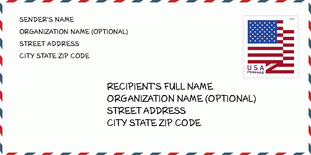
44833-9068 ตัวอย่างซองจดหมาย

-
นี่คือตัวอย่างซองจดหมายของสหรัฐฯ กรอกข้อมูลผู้ส่งที่ด้านบนซ้ายและข้อมูลผู้รับที่ด้านล่างขวา ข้อมูลที่จำเป็นคือชื่อเต็มของผู้ส่ง/ผู้รับ ที่อยู่ เมือง รัฐ และรหัสไปรษณีย์ ข้อมูลที่อยู่ผู้รับได้รับสำหรับการอ้างอิงของคุณ โดยทั่วไป หากคุณไม่แน่ใจเกี่ยวกับรหัสไปรษณีย์ 9 หลักแบบเต็ม คุณสามารถกรอกรหัสไปรษณีย์ 5 หลักเท่านั้นเพื่อหลีกเลี่ยงการสูญหายของพัสดุ
44833-9068 ความหมายพื้นฐาน
-
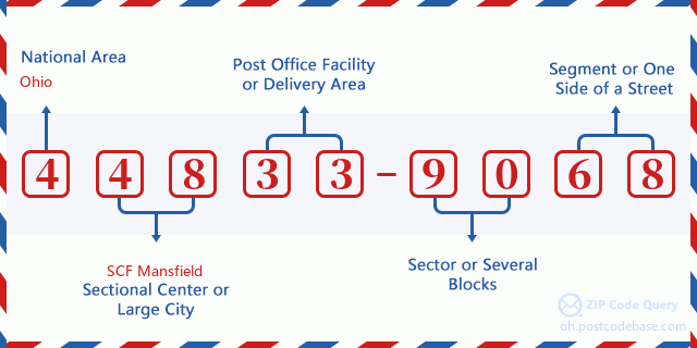
รหัสไปรษณีย์ 44833-9068 แต่ละหลักย่อมาจากอะไร ? รหัสไปรษณีย์ประกอบด้วยสองส่วน โดยสามารถระบุหมายเลขห้าหลักแรกไปยังที่ทำการไปรษณีย์ได้ และตัวเลขสี่หลักสุดท้ายสามารถระบุส่วนทางภูมิศาสตร์ภายในพื้นที่จัดส่งห้าหลักได้ ตัวเลข 6-7 หลักกำหนดส่วนหรือหลายช่วงตึก และตัวเลข 8-9 หลักกำหนดส่วนหรือด้านใดด้านหนึ่งของถนน

- · Idเส้นทางการขนส่ง?
A 4-digit code assigned to a mail delivery or collection route within a 5-digit ZIP Code. The first character of this identification is alphabetical, and the last three are numeric: Bnnn = PO box Hnnn = Highway contract Rnnn = Rural route Cnnn = City delivery Gnnn = General delivery: R004 (สายชนบท)
- ·ภาคต่ำเพิ่มเติมทางไปรษณีย์?
The ZIP Add-On Low Sector and the ZIP Add-On Low Segment together form the ZIP Add-On Low Number. The ZIP Add-On Low Number is the last four positions of a ZIP+4 code; the low-end ZIP add-on in a range of codes; the add-on of the first ZIP+4 code in a consecutive series of ZIP+4 codes assigned to the delivery address. For example, most delivery addresses are assigned a single ZIP+4 code. However, large companies may be given a range of ZIP+4 codes that can be used to route mail to specific departments. A range of ZIP+4 codes can also be assigned to a corresponding range of post office boxes, and each box is mapped, one-to-one, with a ZIP+4 code in the range. A single post office box can also be assigned a range of ZIP+4 codes.: 90
- ·ส่วนต่ำเพิ่มเติมทางไปรษณีย์?
The ZIP Add-On Low Sector and the ZIP Add-On Low Segment together form the ZIP Add-On Low Number. The ZIP Add-On Low Number is the last four positions of a ZIP+4 code; the low-end ZIP add-on in a range of codes; the add-on of the first ZIP+4 code in a consecutive series of ZIP+4 codes assigned to the delivery address. For example, most delivery addresses are assigned a single ZIP+4 code. However, large companies may be given a range of ZIP+4 codes that can be used to route mail to specific departments. A range of ZIP+4 codes can also be assigned to a corresponding range of post office boxes, and each box is mapped, one-to-one, with a ZIP+4 code in the range. A single post office box can also be assigned a range of ZIP+4 codes.: 68
- ·ภาคสูงเพิ่มเติมทางไปรษณีย์?
The ZIP Add-On High Sector and the ZIP Add-On High Segment together form the ZIP Add-On High Number, which is the high-end ZIP add-on in a range of codes; the add-on of the last ZIP+4 code in a consecutive series of ZIP+4 codes assigned to the delivery address. Most delivery addresses are assigned a single ZIP+4 code; however, large companies may be given a range of ZIP+4 codes that can be used to route mail to specific departments. A range of ZIP+4 codes can also be assigned to a corresponding range of post office boxes, and each box is mapped, one-to-one, with a ZIP+4 code in the range. A single post office box can also be assigned a range of ZIP+4 codes. (See also ZIP Add-On Code.): 90
- ·ส่วนสูงเพิ่มเติมทางไปรษณีย์?
The ZIP Add-On High Sector and the ZIP Add-On High Segment together form the ZIP Add-On High Number, which is the high-end ZIP add-on in a range of codes; the add-on of the last ZIP+4 code in a consecutive series of ZIP+4 codes assigned to the delivery address. Most delivery addresses are assigned a single ZIP+4 code; however, large companies may be given a range of ZIP+4 codes that can be used to route mail to specific departments. A range of ZIP+4 codes can also be assigned to a corresponding range of post office boxes, and each box is mapped, one-to-one, with a ZIP+4 code in the range. A single post office box can also be assigned a range of ZIP+4 codes. (See also ZIP Add-On Code.): 68
- ·รหัสไปรษณีย์ เพิ่มเติม: 9068
- ·เทือกเขา?
The range of +4 codes. Summing the +4 Code and the +4 Range will give you the high end of the range of +4 Codes that pertain to this ZIP Code.: 0
- ·รหัสแทนขั้นพื้นฐาน?
Code that specifies whether a record is a base (preferred) or alternate record. Base records (represented as "B") can represent a range of addresses or an individual address, such as a firm record, while alternate records (represented as "A") are individual delivery points. Government deliveries will only be listed on alternate records with the appropriate government building indicator (federal, state, or city) set.: พื้นฐาน
- ·ตัวเลขทางการเงิน?
A code assigned to Postal Service facilities (primarily post offices) to collect cost and statistical data and compile revenue and expense data. The state number comprises the first two positions of the finance number.: 382919
- ·ตัวเลขแขวงรัฐสภา?
A standard value identifying a geographic area within the United States served by a member of the US House of Representatives or Senate. If Army/Air Force (APO) or fleet post office (FPO), this column will be blank. If there is only one member of Congress within a state, the code will be "AL" (at large).: 12
- ·รหัสรัฐเมืองบรรทัดสุดท้าย?
An index to the City State file that provides the preferred last-line name for this address range.: X21096
แผนที่ออนไลน์

นี่คือแผนที่อิเล็กทรอนิกส์ออนไลน์ที่ที่อยู่ 8700 COUNTY ROAD 30 GALIONจับคู่นั้น คุณสามารถจะใช้ปุ่มบนแผนที่เพื่อเลื่อนและซูม ข้อมูลแผนที่นี้ เฉพาะสำหรับการอ้างอิงเท่านั้น
ที่อยู่: 8700 (From 8700 To 8799) COUNTY ROAD 30, GALION, OH 44833-9068, USA
ความเห็น


แสดงความเห็น