Usted está aquí

Dirección: 8801 US HIGHWAY 52, ADAMS COUNTY, OH 45144-8609, USA

¿Qué es 45144-8609? 45144-8609 es un Cógido Postal 5 Más 4 de 8801 US HIGHWAY 52, ADAMS COUNTY, OH, USA. La información detallada se muestra abajo.

45144-8609 Información básica

img_Postal
  • Código Postal 5 Más 4:

    45144-8609
  • Código Postal 5:

    45144
  • Plus 4?
    4-digits that are used to identify a geographic segment within the 5-digit delivery area, such as a city block or a group of apartments or an individual high-volume receiver of mail, or any other unit that could use an extra identifier to aid in efficient mail sorting and delivery. This code is the low end of the range of +4 Codes that pertain to this ZIP Code. ZIP+4 Codes associated with nondelivery areas are composed of valid ZIP sector numbers and "ND" for the ZIP segment number, for example 12345-12ND. Non-deliverable areas are areas to which the USPS does not deliver mail, such as vacant lots and land that borders railroad tracks. Mailers should not match an address identified as a nondelivery area. If you absolutely must have numeric characters in the Plus4Code column, you may treat "ND" values as "00" (zero zero).
    :
    8609
  • País:

    U.S. - Estados Unidos
  • Estado:

    OH - Ohio
  • Condado:

    CountyFIPS: 39001 - Adams County
  • Ciudad:

    ADAMS COUNTY
  • Calle?
    The official name of a street as assigned by a local governing authority. The Street Name column contains only the street name and does not include directionals (EAST, WEST, etc.) or suffixes (ST, DR, BLVD, etc.). This element may also contain literals, such as PO BOX, GENERAL DELIVERY, USS, PSC, or UNIT. Numeric street names that have numeric components that are four characters (or less) in length at are justified such that the low-order digit of the number is positioned in the fourth position of the street name column. This shift is made so that the numeric street names appear in numeric sequence.
    :
    US HIGHWAY 52
  • Nombre de Edificio o Empresa ?
    The name of a company, building, apartment complex, shopping center, or other distinguishing secondary address information. This column is normally used with firm and highrise records but may also contain literals such as "Postmaster" or "United States Postal Service.
    :
    MANCHESTER BOAT DOCK
  • Tipo de Registro?
    An alphabetic value that identifies the type of data in the record. Record type codes include the following: G = General delivery H = Highrise F = Firm S = Street P = PO box R = Rural route/highway contract
    :
    F: Empresa

Dirección

img_region

45144-8609 corresponde a las siguientes direcciones.

Lista de direccionesEstado
8801 US HIGHWAY 52, ADAMS COUNTY, OH 45144-8609, USAválido

Dirección Ejemplo

img_region
La dirección se compone de las siguientes líneas:
8801 US HIGHWAY 52
ADAMS COUNTY OH 45144-8609
UNITED STATES OF AMERICA
o Puede consultar el siguiente ejemplo del sobre para obtener más información.

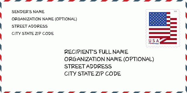
45144-8609 Ejemplo de Sobre

img_envelope
  • Este es un ejemplo de sobre estadounidense. Complete la información del remitente en la parte superior izquierda y la información del destinatario en la parte inferior derecha. La información necesaria es el nombre completo del remitente / destinatario, la dirección postal, la ciudad, el estado y el código postal. La información de la dirección del destinatario se ha proporcionado para su referencia. Generalmente, si no está seguro del código postal completo de 9 dígitos, solo puede completar el código postal de 5 dígitos para evitar la pérdida del paquete.

    ZIP Code: 45144-8609

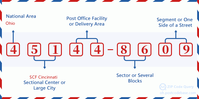
45144-8609 Significado básico

img_envelope
  • ¿Qué significa cada dígito del código postal 45144-8609? El código postal + 4 consta de dos partes, los primeros cinco dígitos se pueden ubicar en la oficina postal y los últimos cuatro dígitos pueden identificar un segmento geográfico dentro del área de entrega de cinco dígitos. Los 6-7 dígitos designan un sector o varios bloques, y los 8-9 dígitos designan un segmento o un lado de una calle.

    ZIP Code: 45144-8609

Mapa en Línea

Mapa en Línea

Esto es el mapa en línea de la dirección 8801 US HIGHWAY 52 ADAMS COUNTY. Podría utilizar el botón para moverse y acercarse / alejarse. La información del mapa sirve sólo como referencia.

Dirección: 8801 US HIGHWAY 52, ADAMS COUNTY, OH 45144-8609, USA

Comentario

Comentario

Añadir nuevo comentario