Adres: 6301 (From 6301 To 6499 Odd) DALEWOOD RD, COLUMBUS, OH 43229-2136, USA
Co to jest 43229-2136? 43229-2136 to kod pocztowy 5 Plus 4 liczba 6301 (From 6301 To 6499 Odd) DALEWOOD RD, COLUMBUS, OH, USA. Bliższe informacje poniżej.
43229-2136 Podstawowe informacje

-
Kod Pocztowy 5 Plus 4:
43229-2136 -
Kod Pocztowy 5:
43229 -
Plus 4?21364-digits that are used to identify a geographic segment within the 5-digit delivery area, such as a city block or a group of apartments or an individual high-volume receiver of mail, or any other unit that could use an extra identifier to aid in efficient mail sorting and delivery. This code is the low end of the range of +4 Codes that pertain to this ZIP Code. ZIP+4 Codes associated with nondelivery areas are composed of valid ZIP sector numbers and "ND" for the ZIP segment number, for example 12345-12ND. Non-deliverable areas are areas to which the USPS does not deliver mail, such as vacant lots and land that borders railroad tracks. Mailers should not match an address identified as a nondelivery area. If you absolutely must have numeric characters in the Plus4Code column, you may treat "ND" values as "00" (zero zero).:
-
Kraj:
U.S. - Stany Zjednoczone -
Państwo/stan:
OH - Ohio -
Hrabstwo:
CountyFIPS: 39049 - Franklin County -
Miasto:
COLUMBUS -
Ulica?DALEWOOD RDThe official name of a street as assigned by a local governing authority. The Street Name column contains only the street name and does not include directionals (EAST, WEST, etc.) or suffixes (ST, DR, BLVD, etc.). This element may also contain literals, such as PO BOX, GENERAL DELIVERY, USS, PSC, or UNIT. Numeric street names that have numeric components that are four characters (or less) in length at are justified such that the low-order digit of the number is positioned in the fourth position of the street name column. This shift is made so that the numeric street names appear in numeric sequence.:
-
Sufiks Ulicy?RD (Droga)The street suffix: For Example: ST = Street RD = Road DR = Drive LN = Lane:
-
Rodzaj Danych?S: UlicaAn alphabetic value that identifies the type of data in the record. Record type codes include the following: G = General delivery H = Highrise F = Firm S = Street P = PO box R = Rural route/highway contract:
Adres

- Prymarny Niski Numer Adresu?
A house, rural route, highway contract box, or post office box number; the numeric or alphanumeric component of an address preceding the street name; the low-end address in a range of addresses. Often referred to as house number.: 6301
- Prymarny Wysoki Numer Adresu?
A house, rural route, contract box, or Post Office box number. The numeric or alphanumeric component of an address preceding the street name. The high-end address in a range of addresses. Often referred to as house number.: 6499
- Nieparzysty/Parzysty Kod Prymarny Adresu?
Code that identifies the side or sides of a street for which a given address range is applicable. For street, highrise, firm and multi-carrier records, B = Both sides of a street, E = Even side of a street (even-numbered addresses in the range); O = Odd side of a street (odd-numbered addresses in the range). For general delivery, post office box, and rural route/highway contract records, this code will always be "B" (both).: Odd
- Podstawowy Zakres: 6301, 6303, 6305, 6307, 6309, 6311, 6313, 6315, 6317, 6319, 6321, 6323, 6325, 6327, 6329, 6331, 6333, 6335, 6337, 6339, 6341, 6343, 6345, 6347, 6349, 6351, 6353, 6355, 6357, 6359, 6361, 6363, 6365, 6367, 6369, 6371, 6373, 6375, 6377, 6379, 6381, 6383, 6385, 6387, 6389, 6391, 6393, 6395, 6397, 6399, 6401, 6403, 6405, 6407, 6409, 6411, 6413, 6415, 6417, 6419, 6421, 6423, 6425, 6427, 6429, 6431, 6433, 6435, 6437, 6439, 6441, 6443, 6445, 6447, 6449, 6451, 6453, 6455, 6457, 6459, 6461, 6463, 6465, 6467, 6469, 6471, 6473, 6475, 6477, 6479, 6481, 6483, 6485, 6487, 6489, 6491, 6493, 6495, 6497, 6499.
Kliknij "Więcej przykładów adresów", aby wyświetlić całą listę.
6301 DALEWOOD RD, COLUMBUS, OH 43229-2136
6303 DALEWOOD RD, COLUMBUS, OH 43229-2136
6305 DALEWOOD RD, COLUMBUS, OH 43229-2136
6307 DALEWOOD RD, COLUMBUS, OH 43229-2136
6309 DALEWOOD RD, COLUMBUS, OH 43229-2136
6311 DALEWOOD RD, COLUMBUS, OH 43229-2136
6313 DALEWOOD RD, COLUMBUS, OH 43229-2136
6315 DALEWOOD RD, COLUMBUS, OH 43229-2136
6317 DALEWOOD RD, COLUMBUS, OH 43229-2136
6319 DALEWOOD RD, COLUMBUS, OH 43229-2136
6321 DALEWOOD RD, COLUMBUS, OH 43229-2136
6323 DALEWOOD RD, COLUMBUS, OH 43229-2136
6325 DALEWOOD RD, COLUMBUS, OH 43229-2136
6327 DALEWOOD RD, COLUMBUS, OH 43229-2136
6329 DALEWOOD RD, COLUMBUS, OH 43229-2136
6331 DALEWOOD RD, COLUMBUS, OH 43229-2136
6333 DALEWOOD RD, COLUMBUS, OH 43229-2136
6335 DALEWOOD RD, COLUMBUS, OH 43229-2136
6337 DALEWOOD RD, COLUMBUS, OH 43229-2136
6339 DALEWOOD RD, COLUMBUS, OH 43229-2136
6341 DALEWOOD RD, COLUMBUS, OH 43229-2136
6343 DALEWOOD RD, COLUMBUS, OH 43229-2136
6345 DALEWOOD RD, COLUMBUS, OH 43229-2136
6347 DALEWOOD RD, COLUMBUS, OH 43229-2136
6349 DALEWOOD RD, COLUMBUS, OH 43229-2136
6351 DALEWOOD RD, COLUMBUS, OH 43229-2136
6353 DALEWOOD RD, COLUMBUS, OH 43229-2136
6355 DALEWOOD RD, COLUMBUS, OH 43229-2136
6357 DALEWOOD RD, COLUMBUS, OH 43229-2136
6359 DALEWOOD RD, COLUMBUS, OH 43229-2136
6361 DALEWOOD RD, COLUMBUS, OH 43229-2136
6363 DALEWOOD RD, COLUMBUS, OH 43229-2136
6365 DALEWOOD RD, COLUMBUS, OH 43229-2136
6367 DALEWOOD RD, COLUMBUS, OH 43229-2136
6369 DALEWOOD RD, COLUMBUS, OH 43229-2136
6371 DALEWOOD RD, COLUMBUS, OH 43229-2136
6373 DALEWOOD RD, COLUMBUS, OH 43229-2136
6375 DALEWOOD RD, COLUMBUS, OH 43229-2136
6377 DALEWOOD RD, COLUMBUS, OH 43229-2136
6379 DALEWOOD RD, COLUMBUS, OH 43229-2136
6381 DALEWOOD RD, COLUMBUS, OH 43229-2136
6383 DALEWOOD RD, COLUMBUS, OH 43229-2136
6385 DALEWOOD RD, COLUMBUS, OH 43229-2136
6387 DALEWOOD RD, COLUMBUS, OH 43229-2136
6389 DALEWOOD RD, COLUMBUS, OH 43229-2136
6391 DALEWOOD RD, COLUMBUS, OH 43229-2136
6393 DALEWOOD RD, COLUMBUS, OH 43229-2136
6395 DALEWOOD RD, COLUMBUS, OH 43229-2136
6397 DALEWOOD RD, COLUMBUS, OH 43229-2136
6399 DALEWOOD RD, COLUMBUS, OH 43229-2136
6401 DALEWOOD RD, COLUMBUS, OH 43229-2136
6403 DALEWOOD RD, COLUMBUS, OH 43229-2136
6405 DALEWOOD RD, COLUMBUS, OH 43229-2136
6407 DALEWOOD RD, COLUMBUS, OH 43229-2136
6409 DALEWOOD RD, COLUMBUS, OH 43229-2136
6411 DALEWOOD RD, COLUMBUS, OH 43229-2136
6413 DALEWOOD RD, COLUMBUS, OH 43229-2136
6415 DALEWOOD RD, COLUMBUS, OH 43229-2136
6417 DALEWOOD RD, COLUMBUS, OH 43229-2136
6419 DALEWOOD RD, COLUMBUS, OH 43229-2136
6421 DALEWOOD RD, COLUMBUS, OH 43229-2136
6423 DALEWOOD RD, COLUMBUS, OH 43229-2136
6425 DALEWOOD RD, COLUMBUS, OH 43229-2136
6427 DALEWOOD RD, COLUMBUS, OH 43229-2136
6429 DALEWOOD RD, COLUMBUS, OH 43229-2136
6431 DALEWOOD RD, COLUMBUS, OH 43229-2136
6433 DALEWOOD RD, COLUMBUS, OH 43229-2136
6435 DALEWOOD RD, COLUMBUS, OH 43229-2136
6437 DALEWOOD RD, COLUMBUS, OH 43229-2136
6439 DALEWOOD RD, COLUMBUS, OH 43229-2136
6441 DALEWOOD RD, COLUMBUS, OH 43229-2136
6443 DALEWOOD RD, COLUMBUS, OH 43229-2136
6445 DALEWOOD RD, COLUMBUS, OH 43229-2136
6447 DALEWOOD RD, COLUMBUS, OH 43229-2136
6449 DALEWOOD RD, COLUMBUS, OH 43229-2136
6451 DALEWOOD RD, COLUMBUS, OH 43229-2136
6453 DALEWOOD RD, COLUMBUS, OH 43229-2136
6455 DALEWOOD RD, COLUMBUS, OH 43229-2136
6457 DALEWOOD RD, COLUMBUS, OH 43229-2136
6459 DALEWOOD RD, COLUMBUS, OH 43229-2136
6461 DALEWOOD RD, COLUMBUS, OH 43229-2136
6463 DALEWOOD RD, COLUMBUS, OH 43229-2136
6465 DALEWOOD RD, COLUMBUS, OH 43229-2136
6467 DALEWOOD RD, COLUMBUS, OH 43229-2136
6469 DALEWOOD RD, COLUMBUS, OH 43229-2136
6471 DALEWOOD RD, COLUMBUS, OH 43229-2136
6473 DALEWOOD RD, COLUMBUS, OH 43229-2136
6475 DALEWOOD RD, COLUMBUS, OH 43229-2136
6477 DALEWOOD RD, COLUMBUS, OH 43229-2136
6479 DALEWOOD RD, COLUMBUS, OH 43229-2136
6481 DALEWOOD RD, COLUMBUS, OH 43229-2136
6483 DALEWOOD RD, COLUMBUS, OH 43229-2136
6485 DALEWOOD RD, COLUMBUS, OH 43229-2136
6487 DALEWOOD RD, COLUMBUS, OH 43229-2136
6489 DALEWOOD RD, COLUMBUS, OH 43229-2136
6491 DALEWOOD RD, COLUMBUS, OH 43229-2136
6493 DALEWOOD RD, COLUMBUS, OH 43229-2136
6495 DALEWOOD RD, COLUMBUS, OH 43229-2136
6497 DALEWOOD RD, COLUMBUS, OH 43229-2136
6499 DALEWOOD RD, COLUMBUS, OH 43229-2136
Adres Przykład
COLUMBUS OH 43229-2136
UNITED STATES OF AMERICA
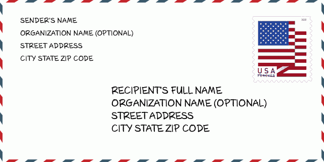
43229-2136 Przykład Koperty

-
To jest przykład koperty amerykańskiej. Wpisz informacje o nadawcy w lewym górnym rogu i informacje o odbiorcy w prawym dolnym rogu. Niezbędne informacje to imię i nazwisko nadawcy/odbiorcy, adres, miasto, województwo i kod pocztowy. Dane adresowe odbiorcy zostały podane w celach informacyjnych. Ogólnie rzecz biorąc, jeśli nie masz pewności co do pełnego 9-cyfrowego kodu pocztowego, możesz wpisać tylko 5-cyfrowy kod pocztowy, aby uniknąć utraty paczki.
43229-2136 Podstawowe znaczenie
-
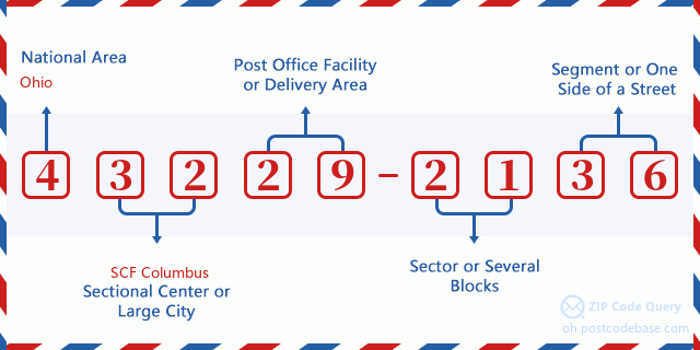
Co oznacza każda cyfra kodu pocztowego 43229-2136? Kod pocztowy + 4 składa się z dwóch części, pierwsze pięć cyfr może znajdować się w urzędzie pocztowym, a ostatnie cztery cyfry mogą identyfikować segment geograficzny w pięciocyfrowym obszarze dostawy. Cyfry 6-7 oznaczają sektor lub kilka bloków, a cyfry 8-9 oznaczają odcinek lub jedną stronę ulicy.

- ·ID Trasy Dostawy?
A 4-digit code assigned to a mail delivery or collection route within a 5-digit ZIP Code. The first character of this identification is alphabetical, and the last three are numeric: Bnnn = PO box Hnnn = Highway contract Rnnn = Rural route Cnnn = City delivery Gnnn = General delivery: C064 (Dostawa Miejska)
- ·Sektor Niski ZIP Dodatku?
The ZIP Add-On Low Sector and the ZIP Add-On Low Segment together form the ZIP Add-On Low Number. The ZIP Add-On Low Number is the last four positions of a ZIP+4 code; the low-end ZIP add-on in a range of codes; the add-on of the first ZIP+4 code in a consecutive series of ZIP+4 codes assigned to the delivery address. For example, most delivery addresses are assigned a single ZIP+4 code. However, large companies may be given a range of ZIP+4 codes that can be used to route mail to specific departments. A range of ZIP+4 codes can also be assigned to a corresponding range of post office boxes, and each box is mapped, one-to-one, with a ZIP+4 code in the range. A single post office box can also be assigned a range of ZIP+4 codes.: 21
- ·Segment Niski ZIP Dodatku?
The ZIP Add-On Low Sector and the ZIP Add-On Low Segment together form the ZIP Add-On Low Number. The ZIP Add-On Low Number is the last four positions of a ZIP+4 code; the low-end ZIP add-on in a range of codes; the add-on of the first ZIP+4 code in a consecutive series of ZIP+4 codes assigned to the delivery address. For example, most delivery addresses are assigned a single ZIP+4 code. However, large companies may be given a range of ZIP+4 codes that can be used to route mail to specific departments. A range of ZIP+4 codes can also be assigned to a corresponding range of post office boxes, and each box is mapped, one-to-one, with a ZIP+4 code in the range. A single post office box can also be assigned a range of ZIP+4 codes.: 36
- ·Sektor Wysoki ZIP Dodatku?
The ZIP Add-On High Sector and the ZIP Add-On High Segment together form the ZIP Add-On High Number, which is the high-end ZIP add-on in a range of codes; the add-on of the last ZIP+4 code in a consecutive series of ZIP+4 codes assigned to the delivery address. Most delivery addresses are assigned a single ZIP+4 code; however, large companies may be given a range of ZIP+4 codes that can be used to route mail to specific departments. A range of ZIP+4 codes can also be assigned to a corresponding range of post office boxes, and each box is mapped, one-to-one, with a ZIP+4 code in the range. A single post office box can also be assigned a range of ZIP+4 codes. (See also ZIP Add-On Code.): 21
- ·Segment Wysoki ZIP Dodatku?
The ZIP Add-On High Sector and the ZIP Add-On High Segment together form the ZIP Add-On High Number, which is the high-end ZIP add-on in a range of codes; the add-on of the last ZIP+4 code in a consecutive series of ZIP+4 codes assigned to the delivery address. Most delivery addresses are assigned a single ZIP+4 code; however, large companies may be given a range of ZIP+4 codes that can be used to route mail to specific departments. A range of ZIP+4 codes can also be assigned to a corresponding range of post office boxes, and each box is mapped, one-to-one, with a ZIP+4 code in the range. A single post office box can also be assigned a range of ZIP+4 codes. (See also ZIP Add-On Code.): 36
- ·PNA Dodatek: 2136
- ·Zakres?
The range of +4 codes. Summing the +4 Code and the +4 Range will give you the high end of the range of +4 Codes that pertain to this ZIP Code.: 0
- ·Kod Alternatywny Bazy?
Code that specifies whether a record is a base (preferred) or alternate record. Base records (represented as "B") can represent a range of addresses or an individual address, such as a firm record, while alternate records (represented as "A") are individual delivery points. Government deliveries will only be listed on alternate records with the appropriate government building indicator (federal, state, or city) set.: Baza
- ·Numer Finansowy?
A code assigned to Postal Service facilities (primarily post offices) to collect cost and statistical data and compile revenue and expense data. The state number comprises the first two positions of the finance number.: 381792
- ·Numer Dystryktu Kongresowego?
A standard value identifying a geographic area within the United States served by a member of the US House of Representatives or Senate. If Army/Air Force (APO) or fleet post office (FPO), this column will be blank. If there is only one member of Congress within a state, the code will be "AL" (at large).: 03
- ·Preferowany Klucz Miasta Stanu Ostatniej Linii?
An index to the City State file that provides the preferred last-line name for this address range.: X20643
Mapa

To mapa sieciowa adresu 6301 DALEWOOD RD, COLUMBUS. Mapę można przybliżyć. Mapa przeznaczona jest wyłącznie dla celów informacyjnych.
Adres: 6301 (From 6301 To 6499 Odd) DALEWOOD RD, COLUMBUS, OH 43229-2136, USA
Komentarz


Dodaj komentarz