Adres: 12900 (From 12900 To 12999) W (West) TOWNSHIP ROAD 84, FOSTORIA, OH 44830-9566, USA
Co to jest 44830-9566? 44830-9566 to kod pocztowy 5 Plus 4 liczba 12900 (From 12900 To 12999) W (West) TOWNSHIP ROAD 84, FOSTORIA, OH, USA. Bliższe informacje poniżej.
44830-9566 Podstawowe informacje

-
Kod Pocztowy 5 Plus 4:
44830-9566 -
Kod Pocztowy 5:
44830 -
Plus 4?95664-digits that are used to identify a geographic segment within the 5-digit delivery area, such as a city block or a group of apartments or an individual high-volume receiver of mail, or any other unit that could use an extra identifier to aid in efficient mail sorting and delivery. This code is the low end of the range of +4 Codes that pertain to this ZIP Code. ZIP+4 Codes associated with nondelivery areas are composed of valid ZIP sector numbers and "ND" for the ZIP segment number, for example 12345-12ND. Non-deliverable areas are areas to which the USPS does not deliver mail, such as vacant lots and land that borders railroad tracks. Mailers should not match an address identified as a nondelivery area. If you absolutely must have numeric characters in the Plus4Code column, you may treat "ND" values as "00" (zero zero).:
-
Kraj:
U.S. - Stany Zjednoczone -
Państwo/stan:
OH - Ohio -
Hrabstwo:
CountyFIPS: 39147 - Seneca County -
Miasto:
FOSTORIA -
Przedkierunkowy Ulicy:
W (West) -
Ulica?TOWNSHIP ROAD 84The official name of a street as assigned by a local governing authority. The Street Name column contains only the street name and does not include directionals (EAST, WEST, etc.) or suffixes (ST, DR, BLVD, etc.). This element may also contain literals, such as PO BOX, GENERAL DELIVERY, USS, PSC, or UNIT. Numeric street names that have numeric components that are four characters (or less) in length at are justified such that the low-order digit of the number is positioned in the fourth position of the street name column. This shift is made so that the numeric street names appear in numeric sequence.:
-
Rodzaj Danych?S: UlicaAn alphabetic value that identifies the type of data in the record. Record type codes include the following: G = General delivery H = Highrise F = Firm S = Street P = PO box R = Rural route/highway contract:
Adres

- Prymarny Niski Numer Adresu?
A house, rural route, highway contract box, or post office box number; the numeric or alphanumeric component of an address preceding the street name; the low-end address in a range of addresses. Often referred to as house number.: 12900
- Prymarny Wysoki Numer Adresu?
A house, rural route, contract box, or Post Office box number. The numeric or alphanumeric component of an address preceding the street name. The high-end address in a range of addresses. Often referred to as house number.: 12999
- Nieparzysty/Parzysty Kod Prymarny Adresu?
Code that identifies the side or sides of a street for which a given address range is applicable. For street, highrise, firm and multi-carrier records, B = Both sides of a street, E = Even side of a street (even-numbered addresses in the range); O = Odd side of a street (odd-numbered addresses in the range). For general delivery, post office box, and rural route/highway contract records, this code will always be "B" (both).: Both of Odd and Even
- Podstawowy Zakres: 12900, 12901, 12902, 12903, 12904, 12905, 12906, 12907, 12908, 12909, 12910, 12911, 12912, 12913, 12914, 12915, 12916, 12917, 12918, 12919, 12920, 12921, 12922, 12923, 12924, 12925, 12926, 12927, 12928, 12929, 12930, 12931, 12932, 12933, 12934, 12935, 12936, 12937, 12938, 12939, 12940, 12941, 12942, 12943, 12944, 12945, 12946, 12947, 12948, 12949, 12950, 12951, 12952, 12953, 12954, 12955, 12956, 12957, 12958, 12959, 12960, 12961, 12962, 12963, 12964, 12965, 12966, 12967, 12968, 12969, 12970, 12971, 12972, 12973, 12974, 12975, 12976, 12977, 12978, 12979, 12980, 12981, 12982, 12983, 12984, 12985, 12986, 12987, 12988, 12989, 12990, 12991, 12992, 12993, 12994, 12995, 12996, 12997, 12998, 12999.
Kliknij "Więcej przykładów adresów", aby wyświetlić całą listę.
12900 W (West) TOWNSHIP ROAD 84, FOSTORIA, OH 44830-9566
12901 W (West) TOWNSHIP ROAD 84, FOSTORIA, OH 44830-9566
12902 W (West) TOWNSHIP ROAD 84, FOSTORIA, OH 44830-9566
12903 W (West) TOWNSHIP ROAD 84, FOSTORIA, OH 44830-9566
12904 W (West) TOWNSHIP ROAD 84, FOSTORIA, OH 44830-9566
12905 W (West) TOWNSHIP ROAD 84, FOSTORIA, OH 44830-9566
12906 W (West) TOWNSHIP ROAD 84, FOSTORIA, OH 44830-9566
12907 W (West) TOWNSHIP ROAD 84, FOSTORIA, OH 44830-9566
12908 W (West) TOWNSHIP ROAD 84, FOSTORIA, OH 44830-9566
12909 W (West) TOWNSHIP ROAD 84, FOSTORIA, OH 44830-9566
12910 W (West) TOWNSHIP ROAD 84, FOSTORIA, OH 44830-9566
12911 W (West) TOWNSHIP ROAD 84, FOSTORIA, OH 44830-9566
12912 W (West) TOWNSHIP ROAD 84, FOSTORIA, OH 44830-9566
12913 W (West) TOWNSHIP ROAD 84, FOSTORIA, OH 44830-9566
12914 W (West) TOWNSHIP ROAD 84, FOSTORIA, OH 44830-9566
12915 W (West) TOWNSHIP ROAD 84, FOSTORIA, OH 44830-9566
12916 W (West) TOWNSHIP ROAD 84, FOSTORIA, OH 44830-9566
12917 W (West) TOWNSHIP ROAD 84, FOSTORIA, OH 44830-9566
12918 W (West) TOWNSHIP ROAD 84, FOSTORIA, OH 44830-9566
12919 W (West) TOWNSHIP ROAD 84, FOSTORIA, OH 44830-9566
12920 W (West) TOWNSHIP ROAD 84, FOSTORIA, OH 44830-9566
12921 W (West) TOWNSHIP ROAD 84, FOSTORIA, OH 44830-9566
12922 W (West) TOWNSHIP ROAD 84, FOSTORIA, OH 44830-9566
12923 W (West) TOWNSHIP ROAD 84, FOSTORIA, OH 44830-9566
12924 W (West) TOWNSHIP ROAD 84, FOSTORIA, OH 44830-9566
12925 W (West) TOWNSHIP ROAD 84, FOSTORIA, OH 44830-9566
12926 W (West) TOWNSHIP ROAD 84, FOSTORIA, OH 44830-9566
12927 W (West) TOWNSHIP ROAD 84, FOSTORIA, OH 44830-9566
12928 W (West) TOWNSHIP ROAD 84, FOSTORIA, OH 44830-9566
12929 W (West) TOWNSHIP ROAD 84, FOSTORIA, OH 44830-9566
12930 W (West) TOWNSHIP ROAD 84, FOSTORIA, OH 44830-9566
12931 W (West) TOWNSHIP ROAD 84, FOSTORIA, OH 44830-9566
12932 W (West) TOWNSHIP ROAD 84, FOSTORIA, OH 44830-9566
12933 W (West) TOWNSHIP ROAD 84, FOSTORIA, OH 44830-9566
12934 W (West) TOWNSHIP ROAD 84, FOSTORIA, OH 44830-9566
12935 W (West) TOWNSHIP ROAD 84, FOSTORIA, OH 44830-9566
12936 W (West) TOWNSHIP ROAD 84, FOSTORIA, OH 44830-9566
12937 W (West) TOWNSHIP ROAD 84, FOSTORIA, OH 44830-9566
12938 W (West) TOWNSHIP ROAD 84, FOSTORIA, OH 44830-9566
12939 W (West) TOWNSHIP ROAD 84, FOSTORIA, OH 44830-9566
12940 W (West) TOWNSHIP ROAD 84, FOSTORIA, OH 44830-9566
12941 W (West) TOWNSHIP ROAD 84, FOSTORIA, OH 44830-9566
12942 W (West) TOWNSHIP ROAD 84, FOSTORIA, OH 44830-9566
12943 W (West) TOWNSHIP ROAD 84, FOSTORIA, OH 44830-9566
12944 W (West) TOWNSHIP ROAD 84, FOSTORIA, OH 44830-9566
12945 W (West) TOWNSHIP ROAD 84, FOSTORIA, OH 44830-9566
12946 W (West) TOWNSHIP ROAD 84, FOSTORIA, OH 44830-9566
12947 W (West) TOWNSHIP ROAD 84, FOSTORIA, OH 44830-9566
12948 W (West) TOWNSHIP ROAD 84, FOSTORIA, OH 44830-9566
12949 W (West) TOWNSHIP ROAD 84, FOSTORIA, OH 44830-9566
12950 W (West) TOWNSHIP ROAD 84, FOSTORIA, OH 44830-9566
12951 W (West) TOWNSHIP ROAD 84, FOSTORIA, OH 44830-9566
12952 W (West) TOWNSHIP ROAD 84, FOSTORIA, OH 44830-9566
12953 W (West) TOWNSHIP ROAD 84, FOSTORIA, OH 44830-9566
12954 W (West) TOWNSHIP ROAD 84, FOSTORIA, OH 44830-9566
12955 W (West) TOWNSHIP ROAD 84, FOSTORIA, OH 44830-9566
12956 W (West) TOWNSHIP ROAD 84, FOSTORIA, OH 44830-9566
12957 W (West) TOWNSHIP ROAD 84, FOSTORIA, OH 44830-9566
12958 W (West) TOWNSHIP ROAD 84, FOSTORIA, OH 44830-9566
12959 W (West) TOWNSHIP ROAD 84, FOSTORIA, OH 44830-9566
12960 W (West) TOWNSHIP ROAD 84, FOSTORIA, OH 44830-9566
12961 W (West) TOWNSHIP ROAD 84, FOSTORIA, OH 44830-9566
12962 W (West) TOWNSHIP ROAD 84, FOSTORIA, OH 44830-9566
12963 W (West) TOWNSHIP ROAD 84, FOSTORIA, OH 44830-9566
12964 W (West) TOWNSHIP ROAD 84, FOSTORIA, OH 44830-9566
12965 W (West) TOWNSHIP ROAD 84, FOSTORIA, OH 44830-9566
12966 W (West) TOWNSHIP ROAD 84, FOSTORIA, OH 44830-9566
12967 W (West) TOWNSHIP ROAD 84, FOSTORIA, OH 44830-9566
12968 W (West) TOWNSHIP ROAD 84, FOSTORIA, OH 44830-9566
12969 W (West) TOWNSHIP ROAD 84, FOSTORIA, OH 44830-9566
12970 W (West) TOWNSHIP ROAD 84, FOSTORIA, OH 44830-9566
12971 W (West) TOWNSHIP ROAD 84, FOSTORIA, OH 44830-9566
12972 W (West) TOWNSHIP ROAD 84, FOSTORIA, OH 44830-9566
12973 W (West) TOWNSHIP ROAD 84, FOSTORIA, OH 44830-9566
12974 W (West) TOWNSHIP ROAD 84, FOSTORIA, OH 44830-9566
12975 W (West) TOWNSHIP ROAD 84, FOSTORIA, OH 44830-9566
12976 W (West) TOWNSHIP ROAD 84, FOSTORIA, OH 44830-9566
12977 W (West) TOWNSHIP ROAD 84, FOSTORIA, OH 44830-9566
12978 W (West) TOWNSHIP ROAD 84, FOSTORIA, OH 44830-9566
12979 W (West) TOWNSHIP ROAD 84, FOSTORIA, OH 44830-9566
12980 W (West) TOWNSHIP ROAD 84, FOSTORIA, OH 44830-9566
12981 W (West) TOWNSHIP ROAD 84, FOSTORIA, OH 44830-9566
12982 W (West) TOWNSHIP ROAD 84, FOSTORIA, OH 44830-9566
12983 W (West) TOWNSHIP ROAD 84, FOSTORIA, OH 44830-9566
12984 W (West) TOWNSHIP ROAD 84, FOSTORIA, OH 44830-9566
12985 W (West) TOWNSHIP ROAD 84, FOSTORIA, OH 44830-9566
12986 W (West) TOWNSHIP ROAD 84, FOSTORIA, OH 44830-9566
12987 W (West) TOWNSHIP ROAD 84, FOSTORIA, OH 44830-9566
12988 W (West) TOWNSHIP ROAD 84, FOSTORIA, OH 44830-9566
12989 W (West) TOWNSHIP ROAD 84, FOSTORIA, OH 44830-9566
12990 W (West) TOWNSHIP ROAD 84, FOSTORIA, OH 44830-9566
12991 W (West) TOWNSHIP ROAD 84, FOSTORIA, OH 44830-9566
12992 W (West) TOWNSHIP ROAD 84, FOSTORIA, OH 44830-9566
12993 W (West) TOWNSHIP ROAD 84, FOSTORIA, OH 44830-9566
12994 W (West) TOWNSHIP ROAD 84, FOSTORIA, OH 44830-9566
12995 W (West) TOWNSHIP ROAD 84, FOSTORIA, OH 44830-9566
12996 W (West) TOWNSHIP ROAD 84, FOSTORIA, OH 44830-9566
12997 W (West) TOWNSHIP ROAD 84, FOSTORIA, OH 44830-9566
12998 W (West) TOWNSHIP ROAD 84, FOSTORIA, OH 44830-9566
12999 W (West) TOWNSHIP ROAD 84, FOSTORIA, OH 44830-9566
Adres Przykład
FOSTORIA OH 44830-9566
UNITED STATES OF AMERICA
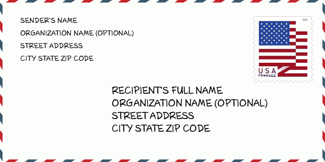
44830-9566 Przykład Koperty

-
To jest przykład koperty amerykańskiej. Wpisz informacje o nadawcy w lewym górnym rogu i informacje o odbiorcy w prawym dolnym rogu. Niezbędne informacje to imię i nazwisko nadawcy/odbiorcy, adres, miasto, województwo i kod pocztowy. Dane adresowe odbiorcy zostały podane w celach informacyjnych. Ogólnie rzecz biorąc, jeśli nie masz pewności co do pełnego 9-cyfrowego kodu pocztowego, możesz wpisać tylko 5-cyfrowy kod pocztowy, aby uniknąć utraty paczki.
44830-9566 Podstawowe znaczenie
-
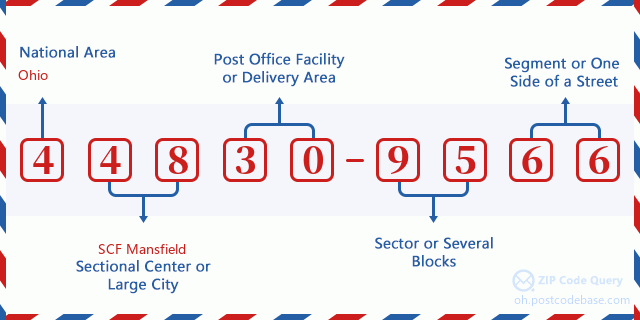
Co oznacza każda cyfra kodu pocztowego 44830-9566? Kod pocztowy + 4 składa się z dwóch części, pierwsze pięć cyfr może znajdować się w urzędzie pocztowym, a ostatnie cztery cyfry mogą identyfikować segment geograficzny w pięciocyfrowym obszarze dostawy. Cyfry 6-7 oznaczają sektor lub kilka bloków, a cyfry 8-9 oznaczają odcinek lub jedną stronę ulicy.

- ·ID Trasy Dostawy?
A 4-digit code assigned to a mail delivery or collection route within a 5-digit ZIP Code. The first character of this identification is alphabetical, and the last three are numeric: Bnnn = PO box Hnnn = Highway contract Rnnn = Rural route Cnnn = City delivery Gnnn = General delivery: R001 (Droga Wiejska)
- ·Sektor Niski ZIP Dodatku?
The ZIP Add-On Low Sector and the ZIP Add-On Low Segment together form the ZIP Add-On Low Number. The ZIP Add-On Low Number is the last four positions of a ZIP+4 code; the low-end ZIP add-on in a range of codes; the add-on of the first ZIP+4 code in a consecutive series of ZIP+4 codes assigned to the delivery address. For example, most delivery addresses are assigned a single ZIP+4 code. However, large companies may be given a range of ZIP+4 codes that can be used to route mail to specific departments. A range of ZIP+4 codes can also be assigned to a corresponding range of post office boxes, and each box is mapped, one-to-one, with a ZIP+4 code in the range. A single post office box can also be assigned a range of ZIP+4 codes.: 95
- ·Segment Niski ZIP Dodatku?
The ZIP Add-On Low Sector and the ZIP Add-On Low Segment together form the ZIP Add-On Low Number. The ZIP Add-On Low Number is the last four positions of a ZIP+4 code; the low-end ZIP add-on in a range of codes; the add-on of the first ZIP+4 code in a consecutive series of ZIP+4 codes assigned to the delivery address. For example, most delivery addresses are assigned a single ZIP+4 code. However, large companies may be given a range of ZIP+4 codes that can be used to route mail to specific departments. A range of ZIP+4 codes can also be assigned to a corresponding range of post office boxes, and each box is mapped, one-to-one, with a ZIP+4 code in the range. A single post office box can also be assigned a range of ZIP+4 codes.: 66
- ·Sektor Wysoki ZIP Dodatku?
The ZIP Add-On High Sector and the ZIP Add-On High Segment together form the ZIP Add-On High Number, which is the high-end ZIP add-on in a range of codes; the add-on of the last ZIP+4 code in a consecutive series of ZIP+4 codes assigned to the delivery address. Most delivery addresses are assigned a single ZIP+4 code; however, large companies may be given a range of ZIP+4 codes that can be used to route mail to specific departments. A range of ZIP+4 codes can also be assigned to a corresponding range of post office boxes, and each box is mapped, one-to-one, with a ZIP+4 code in the range. A single post office box can also be assigned a range of ZIP+4 codes. (See also ZIP Add-On Code.): 95
- ·Segment Wysoki ZIP Dodatku?
The ZIP Add-On High Sector and the ZIP Add-On High Segment together form the ZIP Add-On High Number, which is the high-end ZIP add-on in a range of codes; the add-on of the last ZIP+4 code in a consecutive series of ZIP+4 codes assigned to the delivery address. Most delivery addresses are assigned a single ZIP+4 code; however, large companies may be given a range of ZIP+4 codes that can be used to route mail to specific departments. A range of ZIP+4 codes can also be assigned to a corresponding range of post office boxes, and each box is mapped, one-to-one, with a ZIP+4 code in the range. A single post office box can also be assigned a range of ZIP+4 codes. (See also ZIP Add-On Code.): 66
- ·PNA Dodatek: 9566
- ·Zakres?
The range of +4 codes. Summing the +4 Code and the +4 Range will give you the high end of the range of +4 Codes that pertain to this ZIP Code.: 0
- ·Kod Alternatywny Bazy?
Code that specifies whether a record is a base (preferred) or alternate record. Base records (represented as "B") can represent a range of addresses or an individual address, such as a firm record, while alternate records (represented as "A") are individual delivery points. Government deliveries will only be listed on alternate records with the appropriate government building indicator (federal, state, or city) set.: Baza
- ·Numer Finansowy?
A code assigned to Postal Service facilities (primarily post offices) to collect cost and statistical data and compile revenue and expense data. The state number comprises the first two positions of the finance number.: 382800
- ·Numer Dystryktu Kongresowego?
A standard value identifying a geographic area within the United States served by a member of the US House of Representatives or Senate. If Army/Air Force (APO) or fleet post office (FPO), this column will be blank. If there is only one member of Congress within a state, the code will be "AL" (at large).: 04
- ·Preferowany Klucz Miasta Stanu Ostatniej Linii?
An index to the City State file that provides the preferred last-line name for this address range.: X21051
Mapa

To mapa sieciowa adresu 12900 W (West) TOWNSHIP ROAD 84 FOSTORIA. Mapę można przybliżyć. Mapa przeznaczona jest wyłącznie dla celów informacyjnych.
Adres: 12900 (From 12900 To 12999) W (West) TOWNSHIP ROAD 84, FOSTORIA, OH 44830-9566, USA
Komentarz


Dodaj komentarz