Adres: 5200 (From 5200 To 5299) N (North) TOWNSHIP ROAD 57, FOSTORIA, OH 44830-9534, USA
44830-9534 nedir? 44830-9534 , 5200 (From 5200 To 5299) N (North) TOWNSHIP ROAD 57, FOSTORIA, OH, USA'in bir 5 Artı 4 ZIP KODU numarasıdır. Aşağıda detaylı bilgi yer almaktadır.
44830-9534 Temel Bilgiler

-
Posta Kodu 5 Plus 4:
44830-9534 -
Posta Kodu 5:
44830 -
Plus 4?95344-digits that are used to identify a geographic segment within the 5-digit delivery area, such as a city block or a group of apartments or an individual high-volume receiver of mail, or any other unit that could use an extra identifier to aid in efficient mail sorting and delivery. This code is the low end of the range of +4 Codes that pertain to this ZIP Code. ZIP+4 Codes associated with nondelivery areas are composed of valid ZIP sector numbers and "ND" for the ZIP segment number, for example 12345-12ND. Non-deliverable areas are areas to which the USPS does not deliver mail, such as vacant lots and land that borders railroad tracks. Mailers should not match an address identified as a nondelivery area. If you absolutely must have numeric characters in the Plus4Code column, you may treat "ND" values as "00" (zero zero).:
-
Ülke:
U.S. - Amerika Birleşik Devletleri -
Eyalet:
OH - Ohio -
İlçe:
CountyFIPS: 39147 - Seneca County -
Şehir:
FOSTORIA -
Sokak Predirectional:
N (North) -
Sokak?TOWNSHIP ROAD 57The official name of a street as assigned by a local governing authority. The Street Name column contains only the street name and does not include directionals (EAST, WEST, etc.) or suffixes (ST, DR, BLVD, etc.). This element may also contain literals, such as PO BOX, GENERAL DELIVERY, USS, PSC, or UNIT. Numeric street names that have numeric components that are four characters (or less) in length at are justified such that the low-order digit of the number is positioned in the fourth position of the street name column. This shift is made so that the numeric street names appear in numeric sequence.:
-
Kayıt Türü?S: SokakAn alphabetic value that identifies the type of data in the record. Record type codes include the following: G = General delivery H = Highrise F = Firm S = Street P = PO box R = Rural route/highway contract:
Adres

- Adres Birincil Düşük Numarası?
A house, rural route, highway contract box, or post office box number; the numeric or alphanumeric component of an address preceding the street name; the low-end address in a range of addresses. Often referred to as house number.: 5200
- Adres Birincil Yüksek Numarası?
A house, rural route, contract box, or Post Office box number. The numeric or alphanumeric component of an address preceding the street name. The high-end address in a range of addresses. Often referred to as house number.: 5299
- Adres Birincil Tek / Çift Kodu?
Code that identifies the side or sides of a street for which a given address range is applicable. For street, highrise, firm and multi-carrier records, B = Both sides of a street, E = Even side of a street (even-numbered addresses in the range); O = Odd side of a street (odd-numbered addresses in the range). For general delivery, post office box, and rural route/highway contract records, this code will always be "B" (both).: Both of Odd and Even
- Birincil Dizi: 5200, 5201, 5202, 5203, 5204, 5205, 5206, 5207, 5208, 5209, 5210, 5211, 5212, 5213, 5214, 5215, 5216, 5217, 5218, 5219, 5220, 5221, 5222, 5223, 5224, 5225, 5226, 5227, 5228, 5229, 5230, 5231, 5232, 5233, 5234, 5235, 5236, 5237, 5238, 5239, 5240, 5241, 5242, 5243, 5244, 5245, 5246, 5247, 5248, 5249, 5250, 5251, 5252, 5253, 5254, 5255, 5256, 5257, 5258, 5259, 5260, 5261, 5262, 5263, 5264, 5265, 5266, 5267, 5268, 5269, 5270, 5271, 5272, 5273, 5274, 5275, 5276, 5277, 5278, 5279, 5280, 5281, 5282, 5283, 5284, 5285, 5286, 5287, 5288, 5289, 5290, 5291, 5292, 5293, 5294, 5295, 5296, 5297, 5298, 5299.
Tüm listeyi görmek için lütfen "Daha Fazla Adres Örneği"'e tıklayın
5200 N (North) TOWNSHIP ROAD 57, FOSTORIA, OH 44830-9534
5201 N (North) TOWNSHIP ROAD 57, FOSTORIA, OH 44830-9534
5202 N (North) TOWNSHIP ROAD 57, FOSTORIA, OH 44830-9534
5203 N (North) TOWNSHIP ROAD 57, FOSTORIA, OH 44830-9534
5204 N (North) TOWNSHIP ROAD 57, FOSTORIA, OH 44830-9534
5205 N (North) TOWNSHIP ROAD 57, FOSTORIA, OH 44830-9534
5206 N (North) TOWNSHIP ROAD 57, FOSTORIA, OH 44830-9534
5207 N (North) TOWNSHIP ROAD 57, FOSTORIA, OH 44830-9534
5208 N (North) TOWNSHIP ROAD 57, FOSTORIA, OH 44830-9534
5209 N (North) TOWNSHIP ROAD 57, FOSTORIA, OH 44830-9534
5210 N (North) TOWNSHIP ROAD 57, FOSTORIA, OH 44830-9534
5211 N (North) TOWNSHIP ROAD 57, FOSTORIA, OH 44830-9534
5212 N (North) TOWNSHIP ROAD 57, FOSTORIA, OH 44830-9534
5213 N (North) TOWNSHIP ROAD 57, FOSTORIA, OH 44830-9534
5214 N (North) TOWNSHIP ROAD 57, FOSTORIA, OH 44830-9534
5215 N (North) TOWNSHIP ROAD 57, FOSTORIA, OH 44830-9534
5216 N (North) TOWNSHIP ROAD 57, FOSTORIA, OH 44830-9534
5217 N (North) TOWNSHIP ROAD 57, FOSTORIA, OH 44830-9534
5218 N (North) TOWNSHIP ROAD 57, FOSTORIA, OH 44830-9534
5219 N (North) TOWNSHIP ROAD 57, FOSTORIA, OH 44830-9534
5220 N (North) TOWNSHIP ROAD 57, FOSTORIA, OH 44830-9534
5221 N (North) TOWNSHIP ROAD 57, FOSTORIA, OH 44830-9534
5222 N (North) TOWNSHIP ROAD 57, FOSTORIA, OH 44830-9534
5223 N (North) TOWNSHIP ROAD 57, FOSTORIA, OH 44830-9534
5224 N (North) TOWNSHIP ROAD 57, FOSTORIA, OH 44830-9534
5225 N (North) TOWNSHIP ROAD 57, FOSTORIA, OH 44830-9534
5226 N (North) TOWNSHIP ROAD 57, FOSTORIA, OH 44830-9534
5227 N (North) TOWNSHIP ROAD 57, FOSTORIA, OH 44830-9534
5228 N (North) TOWNSHIP ROAD 57, FOSTORIA, OH 44830-9534
5229 N (North) TOWNSHIP ROAD 57, FOSTORIA, OH 44830-9534
5230 N (North) TOWNSHIP ROAD 57, FOSTORIA, OH 44830-9534
5231 N (North) TOWNSHIP ROAD 57, FOSTORIA, OH 44830-9534
5232 N (North) TOWNSHIP ROAD 57, FOSTORIA, OH 44830-9534
5233 N (North) TOWNSHIP ROAD 57, FOSTORIA, OH 44830-9534
5234 N (North) TOWNSHIP ROAD 57, FOSTORIA, OH 44830-9534
5235 N (North) TOWNSHIP ROAD 57, FOSTORIA, OH 44830-9534
5236 N (North) TOWNSHIP ROAD 57, FOSTORIA, OH 44830-9534
5237 N (North) TOWNSHIP ROAD 57, FOSTORIA, OH 44830-9534
5238 N (North) TOWNSHIP ROAD 57, FOSTORIA, OH 44830-9534
5239 N (North) TOWNSHIP ROAD 57, FOSTORIA, OH 44830-9534
5240 N (North) TOWNSHIP ROAD 57, FOSTORIA, OH 44830-9534
5241 N (North) TOWNSHIP ROAD 57, FOSTORIA, OH 44830-9534
5242 N (North) TOWNSHIP ROAD 57, FOSTORIA, OH 44830-9534
5243 N (North) TOWNSHIP ROAD 57, FOSTORIA, OH 44830-9534
5244 N (North) TOWNSHIP ROAD 57, FOSTORIA, OH 44830-9534
5245 N (North) TOWNSHIP ROAD 57, FOSTORIA, OH 44830-9534
5246 N (North) TOWNSHIP ROAD 57, FOSTORIA, OH 44830-9534
5247 N (North) TOWNSHIP ROAD 57, FOSTORIA, OH 44830-9534
5248 N (North) TOWNSHIP ROAD 57, FOSTORIA, OH 44830-9534
5249 N (North) TOWNSHIP ROAD 57, FOSTORIA, OH 44830-9534
5250 N (North) TOWNSHIP ROAD 57, FOSTORIA, OH 44830-9534
5251 N (North) TOWNSHIP ROAD 57, FOSTORIA, OH 44830-9534
5252 N (North) TOWNSHIP ROAD 57, FOSTORIA, OH 44830-9534
5253 N (North) TOWNSHIP ROAD 57, FOSTORIA, OH 44830-9534
5254 N (North) TOWNSHIP ROAD 57, FOSTORIA, OH 44830-9534
5255 N (North) TOWNSHIP ROAD 57, FOSTORIA, OH 44830-9534
5256 N (North) TOWNSHIP ROAD 57, FOSTORIA, OH 44830-9534
5257 N (North) TOWNSHIP ROAD 57, FOSTORIA, OH 44830-9534
5258 N (North) TOWNSHIP ROAD 57, FOSTORIA, OH 44830-9534
5259 N (North) TOWNSHIP ROAD 57, FOSTORIA, OH 44830-9534
5260 N (North) TOWNSHIP ROAD 57, FOSTORIA, OH 44830-9534
5261 N (North) TOWNSHIP ROAD 57, FOSTORIA, OH 44830-9534
5262 N (North) TOWNSHIP ROAD 57, FOSTORIA, OH 44830-9534
5263 N (North) TOWNSHIP ROAD 57, FOSTORIA, OH 44830-9534
5264 N (North) TOWNSHIP ROAD 57, FOSTORIA, OH 44830-9534
5265 N (North) TOWNSHIP ROAD 57, FOSTORIA, OH 44830-9534
5266 N (North) TOWNSHIP ROAD 57, FOSTORIA, OH 44830-9534
5267 N (North) TOWNSHIP ROAD 57, FOSTORIA, OH 44830-9534
5268 N (North) TOWNSHIP ROAD 57, FOSTORIA, OH 44830-9534
5269 N (North) TOWNSHIP ROAD 57, FOSTORIA, OH 44830-9534
5270 N (North) TOWNSHIP ROAD 57, FOSTORIA, OH 44830-9534
5271 N (North) TOWNSHIP ROAD 57, FOSTORIA, OH 44830-9534
5272 N (North) TOWNSHIP ROAD 57, FOSTORIA, OH 44830-9534
5273 N (North) TOWNSHIP ROAD 57, FOSTORIA, OH 44830-9534
5274 N (North) TOWNSHIP ROAD 57, FOSTORIA, OH 44830-9534
5275 N (North) TOWNSHIP ROAD 57, FOSTORIA, OH 44830-9534
5276 N (North) TOWNSHIP ROAD 57, FOSTORIA, OH 44830-9534
5277 N (North) TOWNSHIP ROAD 57, FOSTORIA, OH 44830-9534
5278 N (North) TOWNSHIP ROAD 57, FOSTORIA, OH 44830-9534
5279 N (North) TOWNSHIP ROAD 57, FOSTORIA, OH 44830-9534
5280 N (North) TOWNSHIP ROAD 57, FOSTORIA, OH 44830-9534
5281 N (North) TOWNSHIP ROAD 57, FOSTORIA, OH 44830-9534
5282 N (North) TOWNSHIP ROAD 57, FOSTORIA, OH 44830-9534
5283 N (North) TOWNSHIP ROAD 57, FOSTORIA, OH 44830-9534
5284 N (North) TOWNSHIP ROAD 57, FOSTORIA, OH 44830-9534
5285 N (North) TOWNSHIP ROAD 57, FOSTORIA, OH 44830-9534
5286 N (North) TOWNSHIP ROAD 57, FOSTORIA, OH 44830-9534
5287 N (North) TOWNSHIP ROAD 57, FOSTORIA, OH 44830-9534
5288 N (North) TOWNSHIP ROAD 57, FOSTORIA, OH 44830-9534
5289 N (North) TOWNSHIP ROAD 57, FOSTORIA, OH 44830-9534
5290 N (North) TOWNSHIP ROAD 57, FOSTORIA, OH 44830-9534
5291 N (North) TOWNSHIP ROAD 57, FOSTORIA, OH 44830-9534
5292 N (North) TOWNSHIP ROAD 57, FOSTORIA, OH 44830-9534
5293 N (North) TOWNSHIP ROAD 57, FOSTORIA, OH 44830-9534
5294 N (North) TOWNSHIP ROAD 57, FOSTORIA, OH 44830-9534
5295 N (North) TOWNSHIP ROAD 57, FOSTORIA, OH 44830-9534
5296 N (North) TOWNSHIP ROAD 57, FOSTORIA, OH 44830-9534
5297 N (North) TOWNSHIP ROAD 57, FOSTORIA, OH 44830-9534
5298 N (North) TOWNSHIP ROAD 57, FOSTORIA, OH 44830-9534
5299 N (North) TOWNSHIP ROAD 57, FOSTORIA, OH 44830-9534
Adres Örnek
FOSTORIA OH 44830-9534
UNITED STATES OF AMERICA
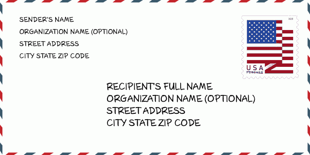
44830-9534 Zarf Örneği

-
Bu, ABD zarfına bir örnektir. Gönderenin bilgilerini sol üstte ve alıcı bilgilerini sağ altta doldurun. Gerekli bilgiler gönderenin/alıcının tam adı, açık adresi, şehri, eyaleti ve posta kodudur. Alıcı adres bilgileri referansınız için verilmiştir. Genel olarak, 9 basamaklı posta kodunun tam olduğundan emin değilseniz, paketin kaybolmasını önlemek için yalnızca 5 basamaklı posta kodunu girebilirsiniz.
44830-9534 Temel Anlam
-
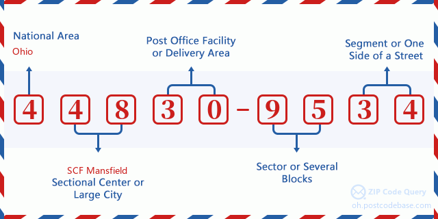
Posta Kodu 44830-9534'in her basamağı ne anlama geliyor? Posta+4 Kodu iki bölümden oluşur, ilk beş basamak postanede bulunabilir ve son dört basamak beş basamaklı teslimat alanı içindeki bir coğrafi segmenti tanımlayabilir. 6-7 basamak, sektörü veya birkaç bloğu belirtir ve 8-9 basamak, bir sokağın segmentini veya bir tarafını belirtir.

- ·Taşıyıcı Rota ID?
A 4-digit code assigned to a mail delivery or collection route within a 5-digit ZIP Code. The first character of this identification is alphabetical, and the last three are numeric: Bnnn = PO box Hnnn = Highway contract Rnnn = Rural route Cnnn = City delivery Gnnn = General delivery: R003 (Kırsal rota)
- ·ZIP Eklenti Düşük Sektör?
The ZIP Add-On Low Sector and the ZIP Add-On Low Segment together form the ZIP Add-On Low Number. The ZIP Add-On Low Number is the last four positions of a ZIP+4 code; the low-end ZIP add-on in a range of codes; the add-on of the first ZIP+4 code in a consecutive series of ZIP+4 codes assigned to the delivery address. For example, most delivery addresses are assigned a single ZIP+4 code. However, large companies may be given a range of ZIP+4 codes that can be used to route mail to specific departments. A range of ZIP+4 codes can also be assigned to a corresponding range of post office boxes, and each box is mapped, one-to-one, with a ZIP+4 code in the range. A single post office box can also be assigned a range of ZIP+4 codes.: 95
- ·ZIP Eklenti Düşük Segment?
The ZIP Add-On Low Sector and the ZIP Add-On Low Segment together form the ZIP Add-On Low Number. The ZIP Add-On Low Number is the last four positions of a ZIP+4 code; the low-end ZIP add-on in a range of codes; the add-on of the first ZIP+4 code in a consecutive series of ZIP+4 codes assigned to the delivery address. For example, most delivery addresses are assigned a single ZIP+4 code. However, large companies may be given a range of ZIP+4 codes that can be used to route mail to specific departments. A range of ZIP+4 codes can also be assigned to a corresponding range of post office boxes, and each box is mapped, one-to-one, with a ZIP+4 code in the range. A single post office box can also be assigned a range of ZIP+4 codes.: 34
- ·ZIP Eklenti Yüksek Sektör?
The ZIP Add-On High Sector and the ZIP Add-On High Segment together form the ZIP Add-On High Number, which is the high-end ZIP add-on in a range of codes; the add-on of the last ZIP+4 code in a consecutive series of ZIP+4 codes assigned to the delivery address. Most delivery addresses are assigned a single ZIP+4 code; however, large companies may be given a range of ZIP+4 codes that can be used to route mail to specific departments. A range of ZIP+4 codes can also be assigned to a corresponding range of post office boxes, and each box is mapped, one-to-one, with a ZIP+4 code in the range. A single post office box can also be assigned a range of ZIP+4 codes. (See also ZIP Add-On Code.): 95
- ·ZIP Eklenti Yüksek Segment?
The ZIP Add-On High Sector and the ZIP Add-On High Segment together form the ZIP Add-On High Number, which is the high-end ZIP add-on in a range of codes; the add-on of the last ZIP+4 code in a consecutive series of ZIP+4 codes assigned to the delivery address. Most delivery addresses are assigned a single ZIP+4 code; however, large companies may be given a range of ZIP+4 codes that can be used to route mail to specific departments. A range of ZIP+4 codes can also be assigned to a corresponding range of post office boxes, and each box is mapped, one-to-one, with a ZIP+4 code in the range. A single post office box can also be assigned a range of ZIP+4 codes. (See also ZIP Add-On Code.): 34
- ·Posta Kodu Eklenti: 9534
- ·Dizi?
The range of +4 codes. Summing the +4 Code and the +4 Range will give you the high end of the range of +4 Codes that pertain to this ZIP Code.: 0
- ·Taban Alternatif Kod?
Code that specifies whether a record is a base (preferred) or alternate record. Base records (represented as "B") can represent a range of addresses or an individual address, such as a firm record, while alternate records (represented as "A") are individual delivery points. Government deliveries will only be listed on alternate records with the appropriate government building indicator (federal, state, or city) set.: Temel
- ·Finans Numarası?
A code assigned to Postal Service facilities (primarily post offices) to collect cost and statistical data and compile revenue and expense data. The state number comprises the first two positions of the finance number.: 382800
- ·Kongre Bölge Numarası?
A standard value identifying a geographic area within the United States served by a member of the US House of Representatives or Senate. If Army/Air Force (APO) or fleet post office (FPO), this column will be blank. If there is only one member of Congress within a state, the code will be "AL" (at large).: 04
- ·Tercih Edilen Son Hat Şehir Durum Anahtarı?
An index to the City State file that provides the preferred last-line name for this address range.: X21051
Çevrimiçi Harita

Bu 5200 N (North) TOWNSHIP ROAD 57 FOSTORIA adresinin çevrimiçi haritasıdır. Hareket ettirmek ve yakınlaştırmak / uzaklaştırmak için düğmeyi kullanabilirsiniz. Harita bilgisi sadece referans içindir.
Adres: 5200 (From 5200 To 5299) N (North) TOWNSHIP ROAD 57, FOSTORIA, OH 44830-9534, USA
Yorum


Yeni yorum ekle