ZIP Code 5: 43910 - BLOOMINGDALE, OH
ZIP Code 43910 is the postal code in BLOOMINGDALE, OH. Besides the basic information, it also lists the full ZIP code and the address of ZIP code 43910. Whatsmore, there is more information related to ZIP Code 43910. For example, nearby ZIP code around ZIP Code 43910, etc.
ZIP 43910 Basic Information

The basic information of ZIP Code 43910 is as follows, including: country, county, city, FIPS and etc.
| State | County | City | ZIP Code 5 |
|---|---|---|---|
| OH - Ohio | Harrison County | BLOOMINGDALE | 43910 |
| OH - Ohio | Jefferson County | BLOOMINGDALE | 43910 |
📌It means zip code 43910 is across counties/cities.
What is the plus 4 zip code for 43910 ZIP Code? Below is the detail.
43910 ZIP+4 Code List

What are the 4 digit zip extensions of ZIP Code 43910? ZIP code 43910 has many plus 4 codes, and each plus 4 code corresponds to one or more addresses. Below we list all the ZIP+4 codes and their addresses in the ZIP Code 43910. You can find a 9-digit ZIP Code by a full address.
| ZIP Code 5 Plus 4 | Address |
|---|---|
| 43910-6807 | 100 (From 100 To 299) COUNTY ROAD 39B, BLOOMINGDALE, OH |
| 43910-6809 | 49800 (From 49800 To 49899) STATE ROUTE 646, BLOOMINGDALE, OH |
| 43910-6810 | 6700 (From 6700 To 7299) STATE ROUTE 646, BLOOMINGDALE, OH |
| 43910-6811 | 500 (From 500 To 599) TOWNSHIP ROAD 216, BLOOMINGDALE, OH |
| 43910-6812 | 8900 (From 8900 To 8999) COUNTY ROAD 39, BLOOMINGDALE, OH |
| 43910-68ND | 48800 (From 48800 To 48899) STATE ROUTE 646, BLOOMINGDALE, OH |
| 43910-6900 | 1900 (From 1900 To 1949) COUNTY ROAD 22A, BLOOMINGDALE, OH |
| 43910-6901 | 1950 (From 1950 To 1999) COUNTY ROAD 22A, BLOOMINGDALE, OH |
| 43910-6902 | 1600 (From 1600 To 2099) STATE ROUTE 152, BLOOMINGDALE, OH |
| 43910-6903 | 1500 (From 1500 To 1599) STATE ROUTE 152, BLOOMINGDALE, OH |
Post Office in ZIP Code 43910

BLOOMINGDALE is the only post office in ZIP Code 43910. You can find the address, phone number, and interactive map below. Click to view the service and service hours about BLOOMINGDALE.
-
BLOOMINGDALE Post Office

Address 111 HIGH ST, BLOOMINGDALE, OH, 43910-9800
Phone 740-944-1753
*Lot Parking Available
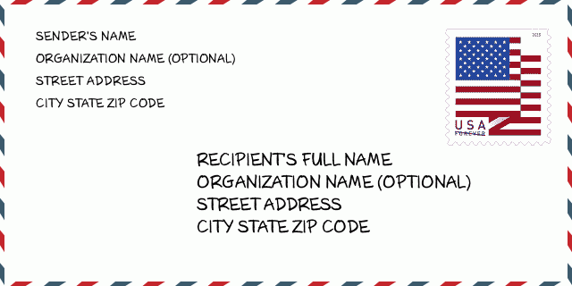
How to write a U.S. envelope?

-
First, you need to fill in the recipient's mailing information in the center of the envelope. The first line is the recipient's name, the second line is the street address with a detailed house number, and the last line is the city, state abbr, and ZIP Code.
Second, write the sender's information on the left top corner of the envelope. If your mail cannot be delivered, it will return to the sender's address.
Finally, don't forget to stick the stamp on the right top corner. Otherwise, the letter will not go into the delivery process.
Here is the envelope example below.
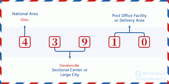
What does each digit of ZIP Code 43910 stand for?
-
The first digit designates a national area, which ranges from zero for the Northeast to nine for the far West.
The 2-3 digits represent a sectional center facility in that region.
The last two digits designate small post offices or postal zones.
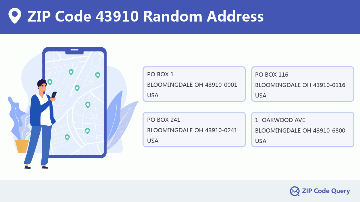
Random Address in ZIP 43910

ZIP Code 43910 has 362 real random addresses, you can clicking the picture below to get random addresses in ZIP Code 43910.
ZIP 43910 Online Map

This is online map of the address BLOOMINGDALE, Harrison County, Ohio. You may use button to move and zoom in / out. The map information is for reference only.
ZIP 43910 NearBy ZIP Code
The Nearby ZIP Codes are 43944, 43953, 43925, 43976, and 43952, you can find ZIP codes in a 25km radius around ZIP Code 43910 and the approximate distance between the two ZIP codes.
The data has a slight deviation for your reference only.
| ZIP Code | Distance (Kilo Meters) |
|---|---|
| 43944 | 5.536 |
| 43953 | 8.896 |
| 43925 | 9.695 |
| 43976 | 9.953 |
| 43952 | 10.311 |
| 43948 | 12.187 |
| 43941 | 12.229 |
| 43970 | 12.741 |
| 43938 | 13.557 |
| 43908 | 14.774 |
| 43903 | 16.115 |
| 43964 | 16.472 |
| 43917 | 16.563 |
| 43986 | 16.741 |
| 43932 | 16.742 |
| 43943 | 16.833 |
| 43901 | 17.959 |
| 43913 | 18.335 |
| 26037 | 18.892 |
| 26062 | 19.212 |
| 26035 | 19.839 |
| 43984 | 20.238 |
| 43926 | 20.412 |
| 43961 | 21.681 |
| 43930 | 22.257 |
| 43939 | 22.427 |
| 26030 | 22.51 |
| 43907 | 22.688 |
| 26070 | 22.966 |
| 26047 | 23.274 |
| 43974 | 23.391 |
| 26075 | 23.488 |
| 26058 | 23.755 |
| 43963 | 24.52 |
| 43971 | 24.996 |

Museum in ZIP Code 43910

-
AMERICAN HERITAGE MUSEUM
Phone: (740) 765-4750Discipline: Uncategorized or General MuseumsAddress: 2423 TOWNSHIP HIGHWAY 220, BLOOMINGDALE OH 43910, USA
School in ZIP Code 43910

This is the ZIP Code 43910 - School page list. Its detail School Name, Address, City, State, ZIP Code is as below.
| School Name | Address | City | State | Grades | ZIP Code |
|---|---|---|---|---|---|
| Jefferson County | 1509 County Highway 22a | Bloomingdale | Ohio | 11-12 | 43910 |
| Wayne Elementary School | 5926 County Road 22a | Bloomingdale | Ohio | PK-6 | 43910 |
Comment


Add new comment